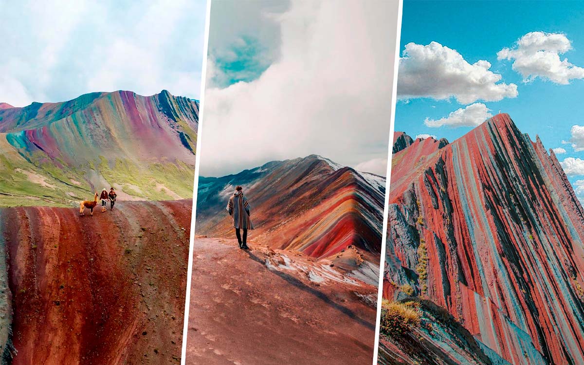
The colored mountains are geological formations where layers of sediment with different minerals were exposed by erosion, creating stripes of red, green, yellow, and purple in the rock. In the region of Cusco there are at least three places with this phenomenon: Vinicunca, Palcoyo, and Pallay Punchu. Each one has a different location, altitude, and level of difficulty, which creates a common doubt among travelers: which one to visit if you only have one day?
The reason why there are several options with similar characteristics is geological; the same composition of Andean soils repeats in different points of the mountain range. However, the best known one, Vinicunca, concentrates most of the visits, while Palcoyo and Pallay Punchu offer alternatives with fewer crowds.
This article compares the three destinations based on distance from Cusco, altitude, hiking difficulty, and approximate cost, so that the choice depends on concrete data and not just on which one appears first in a search.
Getting to Know the Colored Mountains in Peru
Cusco and its surroundings concentrate three formations of this type, each with different access, difficulty, and crowd levels. Vinicunca is the most visited and the one that popularized the phenomenon internationally, Palcoyo offers an alternative with lower altitude and a shorter hike, while Pallay Punchu, located closer to Puno, is the least traveled of the three.
The choice between them depends on concrete factors: available time, physical condition, and altitude tolerance. Now we will get to know each of these 3 colored mountains in Peru:
Vinicunca, the Mountain of 7 Colors
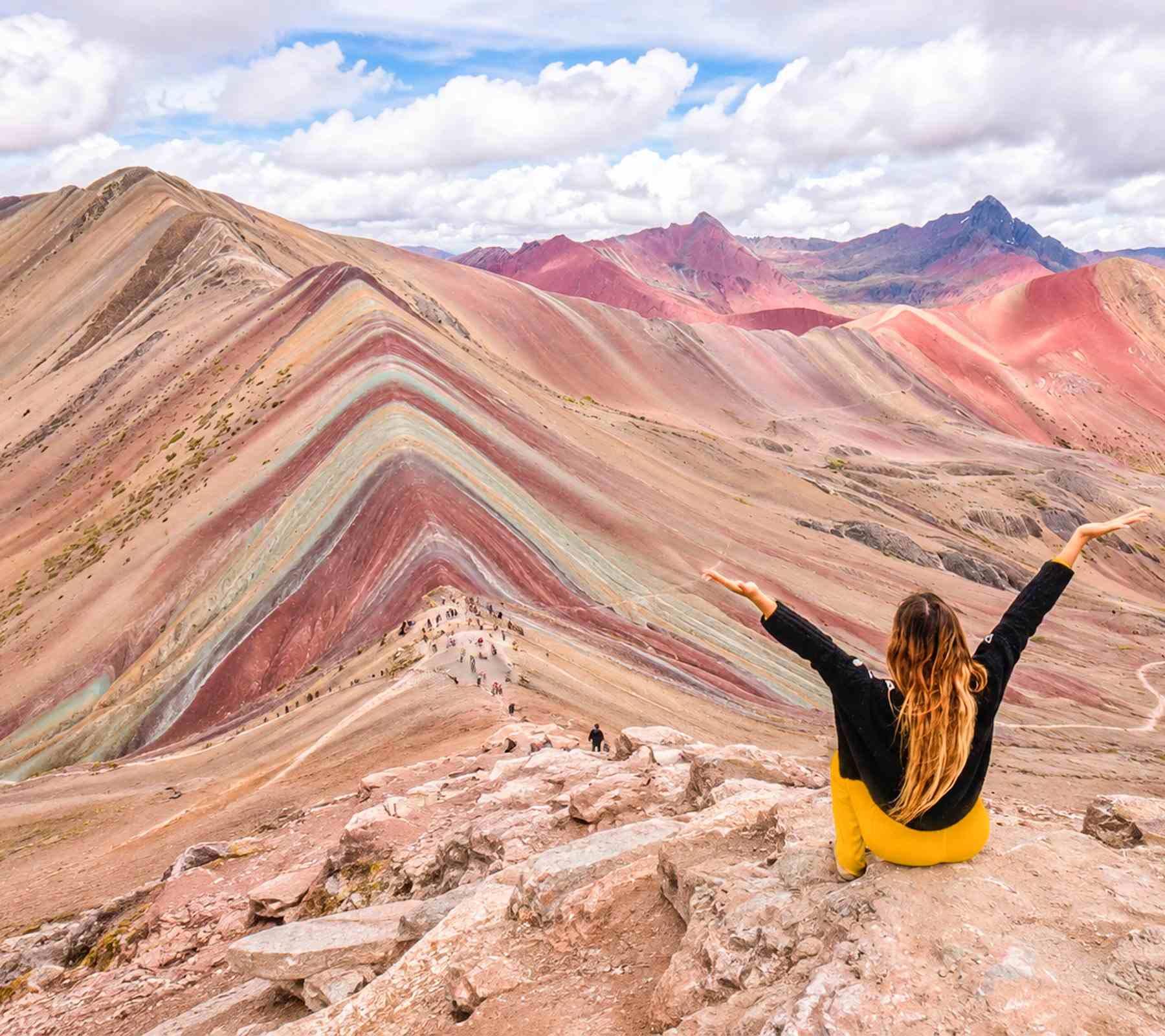
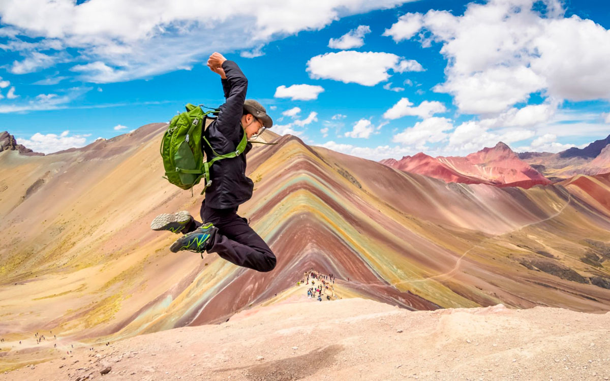
Vinicunca, also known as the Mountain of 7 Colors or Rainbow Mountain, is the geological formation that popularized this type of tourism in Peru. It is located in the province of Quispicanchi, within the Vilcanota Mountain Range, and owes its name to the mineral layers of the rock (iron, sulfur, and other compounds) that create the visible color stripes on the surface: red, pink, yellow, green, brown, white, and turquoise tones predominate.
Although the mountain has always existed, it remained practically unknown to tourism until 2016, when it began to appear in international media and positioned itself as one of the most sought-after destinations in Cusco.
Facts about the mountain
- Distance from Cusco: Approximately 100 km (2.5-3 hours by vehicle to the starting point of the hike)
- Altitude of the main viewpoint: About 5,200 meters above sea level
- Hiking time: 1.5-2 hours up, 3-4 hours round trip
- Difficulty: Moderate-high, mainly due to the altitude
- Starting point: Community of Pampachiri or Chillca, depending on the operator
What is the hike like?
The path crosses high-Andean plains where llamas, alpacas and vicuñas can usually be seen grazing freely. For a good part of the trip, the Ausangate snow-capped peak is visible on the horizon, adding a constant reference point during the hike.
The trail is made of dirt, with a constant slope from the beginning. It does not require technical gear, but breathing effort increases notably in the final stretches due to the altitude. Most operators organize departures from Cusco between 3:00 and 4:00 a.m., to get to the viewpoint before the area gets crowded with visitors and before clouds cover the color stripes, something frequent later in the morning.
Best time to visit
The dry season (May to September) offers a higher chance of clear skies and, therefore, better visibility of the colors. In the rainy season, the mountain stays open, but the fog can cover the viewpoint more often.
Palcoyo Rainbow Mountain
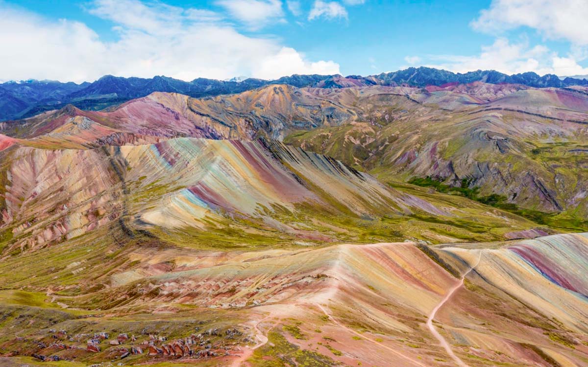
Palcoyo is an alternative to Vinicunca located in the Checacupe district, also in the Canchis province, about 100 km from Cusco. Unlike the 7 color mountain, it is not a single mountain but a range formed by three colorful mountains visible from a single viewpoint, which sometimes leads to describing it (inaccurately) as "the second rainbow mountain".
Mountain facts
- Distance from Cusco: Approximately 100 km (2-2.5 hours by vehicle)
- Altitude of the main viewpoint: Near 4,900 meters above sea level
- Hiking time: 30-45 minutes up, 1-1.5 hours round trip
- Difficulty: Low-moderate
- Starting point: Palcoyo community or Quesillo Chayoc, depending on the operator
What is the hike like?
Before reaching the viewpoint, the route crosses the Red Valley and a stone forest with sharp-pointed rock formations. From the highest point of the route (near 4,900 meters above sea level) you can see the Ausangate snow-capped mountain, the highest mountain in the Cusco region at 6,372 meters above sea level.
The trail is short and has a much smaller slope than Vinicunca. It is suitable for most visitors, including people with basic physical fitness, as long as they are used to the altitude of Cusco. It does not require special gear, and the slower pace allows stopping often to take pictures without the pressure of other groups moving forward behind.
Advantage over Vinicunca
The mix of lower altitude, shorter hike, and lower difficulty makes it a good option for travelers with limited time, families with children, or people who prefer to lower the risk of altitude sickness.
Best time to visit
Just like Vinicunca, the dry season (May to September) offers better visibility. Due to the lower altitude, the fog usually clears more easily even in the rainy season.
Pallay Punchu Mountain
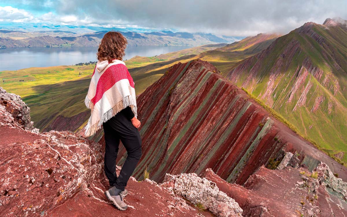
Pallay Punchu is the least known of the three colorful mountains. It is located in the Puno region, Pitumarca district (border between Cusco and Puno), closer to Titicaca than the other two formations.
Unlike Vinicunca and Palcoyo, it did not become popular through tourism promotion but by a accidental find. During the quarantine, a local resident went out to look for medicinal plants near the Langui Lagoon and came across a mountain with sharp edges and intense colors. He shared photos and videos on social media, which generated enough interest to position it, in a short time, as the third rainbow mountain in the region.
Its name also comes from its look, the arrangement of color stripes over the pointed ridges reminds of the design of a woven Andean poncho, hence "Pallay Punchu" ("decorated poncho" in Quechua).
Mountain facts
- Distance from Cusco: Approximately 140-150 km (3.5-4 hours by vehicle)
- Altitude of the main viewpoint: Near 5,100 meters above sea level
- Hiking time: 1-1.5 hours up, 2-3 hours round trip
- Difficulty: Moderate
- Starting point: Chillca community or Pitumarca, depending on the operator
What is the hike like?
Before the hike, the route passes by the Langui Lagoon, with blue waters, which works as a middle stop with its own landscape before continuing towards the climb. From there, the hike takes about two hours to the top, with panoramic views that open up step by step and let you clearly tell apart the mountain stripes, where cyan, brown, and magenta tones stand out.
The trail mixes dirt and rock sections, with a smaller slope than Vinicunca but bigger than Palcoyo. Being in a less traveled area, the signs are more limited, so most visitors go with a guide or local operator.
Combination with Puno and Titicaca
Due to its closeness to Puno, Pallay Punchu is a practical option for those who already have a visit to Lake Titicaca planned, instead of a separate trip from Cusco. Many travelers choose to include this mountain as a stop on the Cusco-Puno route, using the same transfer to see the Uros or Taquile floating islands once at the lake.
Best time to visit
The dry season (May to September) is still the most recommended for visibility, although the lower number of visitors makes occasional fog less important for the general experience, as it does not depend on arriving before other groups.
Comparison table
Choosing between these three mountains depends on how much you value each factor: closeness to Cusco, level of physical effort, chance of running into crowds, or time available in your itinerary.
The following table sums up the key facts of the three mountains to make direct comparison easier before deciding which one fits your trip best:
| Vinicunca | Palcoyo | Pallay Punchu | |
| Distance from Cusco | ~100 km (2.5-3 h) | ~100 km (2-2.5 h) | ~140-150 km (3.5-4 h) |
| Viewpoint altitude | ~5,200 m a.s.l. | ~4,900 m a.s.l. | ~5,100 m a.s.l. |
| Hiking time (round trip) | 3-4 hours | 1-1.5 hours | 2-3 hours |
| Difficulty | Moderate-high | Low-moderate | Moderate |
| Tourist influx | High | Medium-low | Very low |
Practical recommendations
Regardless of which of the three mountains you choose, there are common factors that affect the experience and that are a good idea to check before leaving Cusco.
Altitude sickness
The three mountains are over 4,900 meters above sea level, a height considerably higher than Cusco (3,400 meters above sea level). Even if you are used to the city, the extra climb can cause symptoms of altitude sickness, especially in Vinicunca since it is the highest.
Best time to go
The visibility of the colors depends directly on the weather: clear skies show the stripes with more sharpness, while fog or rain can cover the viewpoint completely. Before setting a date, it is a good idea to check the weather pattern in the region at Cusco Peru Weather.
What to bring on this trip?
The temperature changes sharply between the start from Cusco (still early in the morning and cold) and the hours of strongest sun exposure at the viewpoint. So, among the most important options to bring on this trip are:
- Dressing in layers, this allows you to adjust to that change without carrying unnecessary gear.
- Sun radiation at this height is stronger than usual, so sunscreen should not be put on just upon arrival, but reapplied during the hike.
- Water, on the other hand, is more crucial than on a sea-level hike: the extra breathing effort due to the height speeds up dehydration even on short trails like the one to Palcoyo.
Frequently asked questions about Vinicunca, Palcoyo and Pallay Punchu
- Which is the easiest rainbow mountain to visit?
Palcoyo is the most accessible of the three. The hike to the viewpoint takes between 30 and 45 minutes, with a moderate slope, well below the effort required by Vinicunca. It is the most suitable option for families with children, older adults, or travelers with no prior experience hiking at high altitude. - Which one has fewer tourists?
Pallay Punchu gets the lowest number of visitors of the three, having been added more recently to the region's tourist circuits. Its formation has a different stripe pattern than Vinicunca, with a narrower profile. But keep in mind that having fewer visitors also means less infrastructure along the way (signs, rest spots), so going with a guide or local operator is recommended. - Which is the highest rainbow mountain?
Vinicunca, with a viewpoint located around 5,200 meters above sea level. It is also the one that requires the most physical effort due to the mix of height and slope. At that height, anyone's physical performance drops, regardless of their usual physical fitness; a slow pace during the climb is normal and does not mean a lack of preparation. - Which is the best time of the year to visit?
The dry season, between May and September roughly, offers a higher chance of a clear sky and better visibility of the colors. Between November and March, the trail can get slippery from rain and fog covers the landscape more often. But keep in mind that, even in the dry season, mornings are usually clearer than midday hours, so most tours leave Cusco before sunrise. - How much does it cost to visit Vinicunca, Palcoyo and Pallay Punchu?
Entrance fees are managed directly by local community members at control booths. Vinicunca has a different rate of S/ 15 for Peruvian tourists and S/ 25 for foreigners. Palcoyo, on the other hand, has a cost of S/ 10 for nationals and S/ 20 for foreigners. Although Pallay Punchu started as a free route due to its recent discovery, the community of Layo has set a formal entrance ticket of S/ 10 general for all visitors.
Combine your trip to these mountains with other destinations
If your itinerary in Cusco includes several days, the rainbow mountains can be combined with other nearby destinations without needing to completely rearrange the trip, since they share similar logistics starting points.
-
Humantay Lake
Humantay is one of the destinations most combined with Vinicunca, as they share part of the access route from Cusco. Both offer high mountain landscapes, although Humantay focuses on a glacial-origin lagoon instead of mineral formations. -
Sacred Valley
The Sacred Valley is another frequent option to combine, especially with Palcoyo, since both are located in a similar direction from Cusco. This allows planning an itinerary that includes archaeological sites and traditional markets on the same day or on consecutive days, without long extra trips.