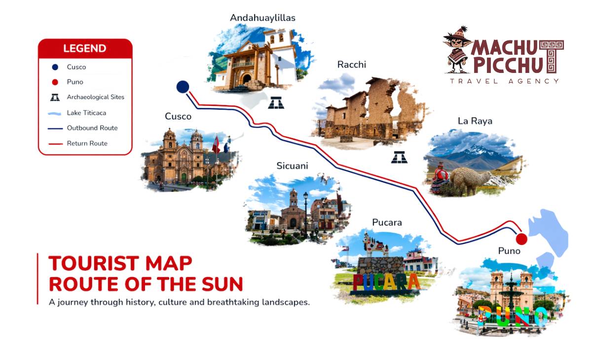
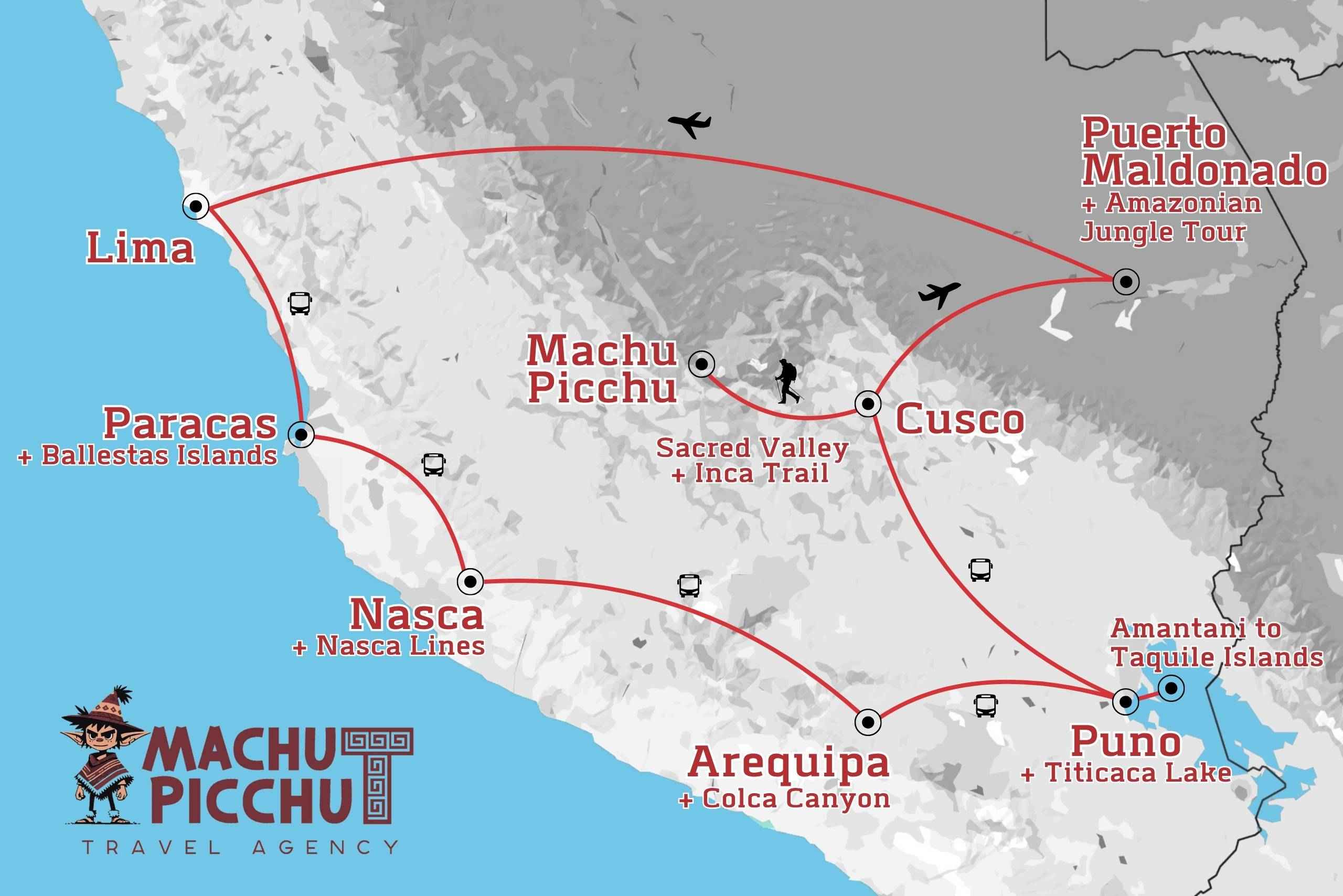
The Inca road network was a system of roads that linked the most important points of the immense Inca Empire. This network of trails is called the Qhapac Ñan, a Quechua word meaning "way of the king" or "way of the powerful." Many sections of these roads remain in good condition and are preserved by several South American countries. The network is considered a World Heritage Site by UNESCO. Today, part of this route ends in Machu Picchu.
What is the Inca trail network?
The Inca road network, known in the Quechua language as qhapac (meaning "main road" or "path of the powerful"), is an immense system of trails built mostly by Emperor Pachacutec in the 15th century.
These roads connected the major cities of the empire to Cusco, its capital. The Inca himself traveled from the "sacred city" to various points in the empire via the Qhapac Ñan.
The Inca road network covered parts of the current countries of Peru, Bolivia, Ecuador, Colombia, Chile, and Argentina. Due to their historical importance, they are currently considered "Cultural Heritage of Humanity" by UNESCO. Because of this, they are protected and preserved for future generations.
What was the importance of the Qhapac Ñan?
The word qhapaqñan defines the road system of the Inca civilization. It is the best evidence of the Incas' advanced civil engineering skills. Notably, this network of roads was built in one of the most rugged territories in the world. It crossed the rugged Andes Mountains and the arid deserts of the South American coast.
The network crossed the Inca Empire from north to south along the coast and through the Andes Mountains. There were small sections designated for the general population. There were also wide sections dedicated to Inca royalty. The mountain roads had completely paved sections, while the coastal roads were simply made of earth.
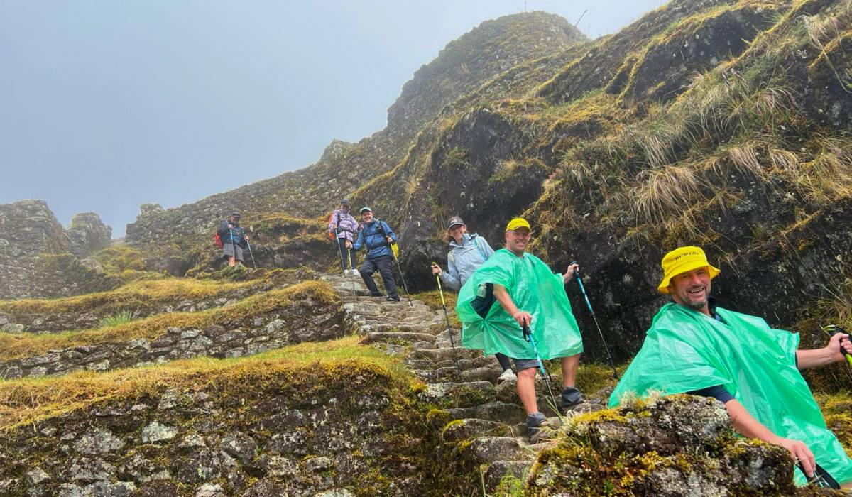
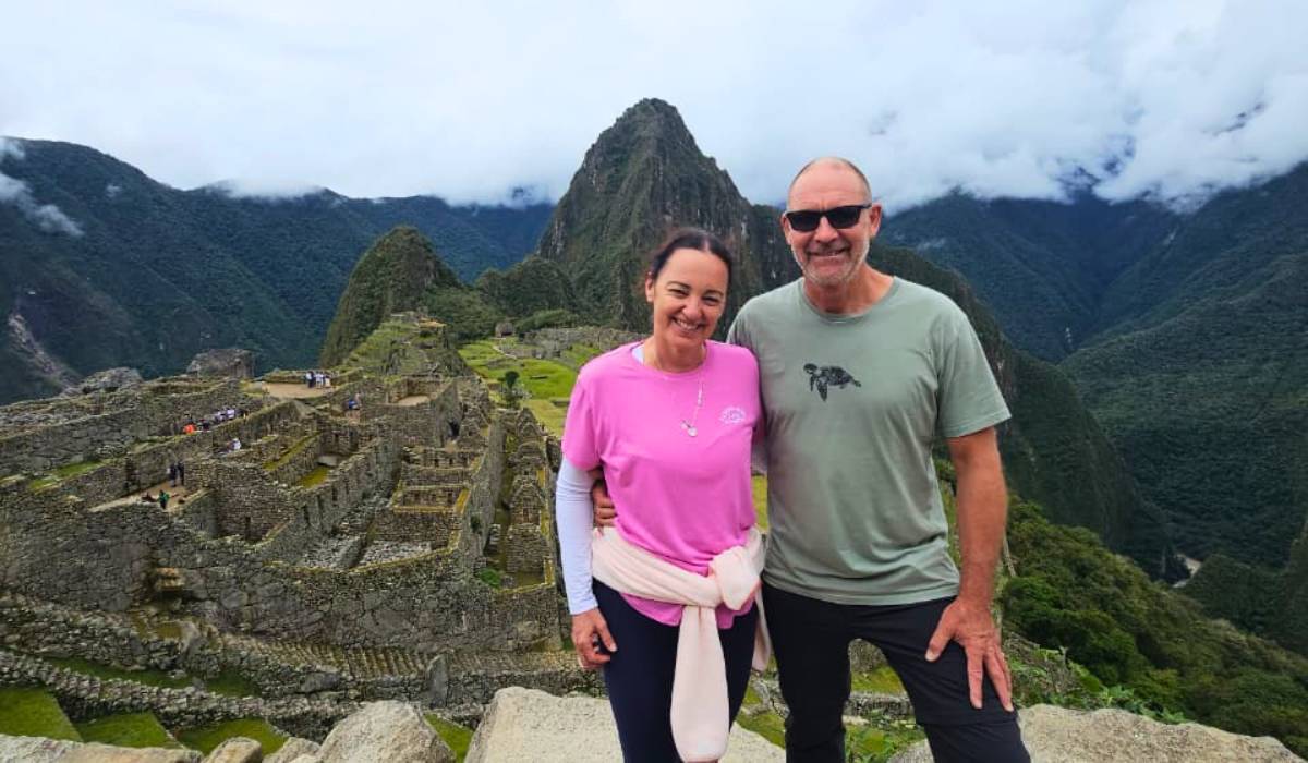
The world-famous Inca Trail to Machu Picchu is just one part of this complex network. Travel up the Urubamba River basin to the Inca city after winding through difficult mountains. Currently, it is considered the best hiking route in Peru. You can visit it in four days on a perfectly planned tour.
What are the lengths of these roads?
Currently, more than 60 thousand kilometers of the roads that comprise this vast network have been identified. However, studies reveal that the Qhapaq Ñan is more than twice as extensive as previously thought.
What was its function?
In addition to connecting one town with another, the route of the roads served to connect the cultures of the towns of that time. Similarly, they served as trade routes and strategic connections between the different towns of the immense Inca Empire. Inca cities such as Vilcashuaman, Pumapampa, Huánuco Pampa, Cajamarca, and Quito.
The Qhapaq Ñan has many sections with two parallel roads on a main route. The Inca, his court, and his armies traveled on one road, while the other was used by the people.
What is its design?
The Qhapac Ñan were designed in response to the coastal and mountainous geography. They wind through immense arid plains and the most rugged mountains of the Andes. The landscape also includes countless slopes, cliffs, mountains, pampas, swamps, gorges, and canyons. In many cases, difficult sections were overcome with bridges and uneven roads.
Construction along the roads
- The difficult geography of South America and the immense distances traveled by the Qhapac Ñan forced the Incas to build structures necessary for the roads to function properly.
Bridges: Several bridges allowed for the crossing of rivers or abysses. These bridges were woven from straw, specifically the wild Andean variety known as "icchu," and were characterized by their hanging design. Other bridges were built with tree trunks supported by huge stone abutments. Also noteworthy are the "oroyas," wooden rafts used to cross lakes. The Queswachaka Bridge in Cusco is currently an example of the Andean tradition of constructing and maintaining Inca bridges.
- The tambos: These structures served as shelters and warehouses for food, wool, firewood, and clothing. These products were stored for travelers and for emergencies. It is estimated that there were dairy farms every 20 or 30 kilometers along the main roads. The tambos housed the "chasquis," young runners who carried the Inca's messages through a relay system. It is said that, through this system, a message could travel from Cusco to Ecuador (approximately 2,000 kilometers) in 10 days.
The roads to Machu Picchu
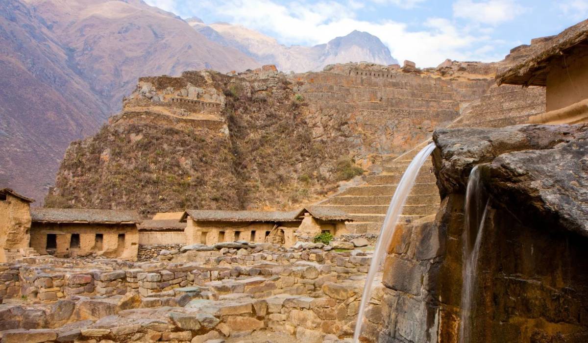
The Inca Trail is a network of small roads connecting the town of Cusco to the Inca city of Machu Picchu. When this archaeological site was discovered in 1911, part of the Qhapac Ñan was unearthed. Since then, these trails have been valued.
Due to its location on the slopes of mountain ranges, this section of the Inca Trail was built according to the characteristics of mountain roads. First, the Incas made the layout of the road, then they laid the foundation with several layers of stone and earth. Next, they made the paving and drainage systems. Because of their complex construction, these trails have remained in good condition.
This section of the Inca Trail was not discovered by the Spanish. It is also believed that the Spanish did not recognize its importance. In any case, the Spanish never reached Machu Picchu, which was abandoned and hidden by thick vegetation over the years. The section from Qhapac Ñan to the Inca city suffered the same fate.
Frequently Asked Questions About the Inca Trail
Do you need to make an advance reservation for the Inca Trail?
Yes! It is highly recommended that you make a reservation for the Inca Trail well in advance. Check the available spaces online and pay your entrance fee.
Book the Inca Trail!
It's crucial to book this hike well in advance!
As a general recommendation, book at least:
- If you want to walk in December, January, or March: - 3 to 5 weeks in advance for December, January, and March
- 6 to 8 weeks in advance for April, October, and November
- 2 to 3 months in advance for May, September
- Not available for June, July, and August Three to four months in advance.
- The Inca Trail is closed in February due to rain. However, you can still visit Machu Picchu by train or on alternative excursions.
How long is the Inca Trail to Machu Picchu?
The Inca Trail to Machu Picchu is 42 kilometers (26 miles) long. Campsites along the trail are assigned by the Ministry of Culture (INC), so it is difficult to determine how far you will have to walk each day. However, you can expect to walk six to nine hours per day.
Will I experience altitude sickness?
Altitude sickness, also known as mountain sickness, rarely affects our visitors since we recommend acclimatizing for two days before trekking.
They should avoid drinking alcohol and drink plenty of water. They should also take altitude sickness pills prescribed by their doctor. If the sickness is more serious, we must return to a medical facility for treatment.
Is it possible to do the Inca Trail without an agency?
Since June 2002, independent trekking has been prohibited on the Inca Trail. According to the regulations, each hiker must be accompanied by a qualified professional guide. The Ministry of Culture of Machu Picchu is the regulatory body responsible for controlling access to Machu Picchu and the Inca Trail.
Businesses must demonstrate that they have professional guides, good camping equipment, radio communicators, and knowledge of emergency first aid, including the use of oxygen. Licenses are renewed every year in early March.
Can I enter with a different name?
NO, you must carry valid identification, such as a passport or DNI, to enter the Inca Trail Circuit to Machu Picchu. Make sure to bring your passport and get the Machu Picchu stamp at the entrance.
Where should you sleep during the Inca Trail?
During the Inca Trail, our team of porters will set up the camping tents. You only need to bring a sleeping bag and a mattress or an inflatable mattress. The porters carry all the necessary camping equipment so you can enjoy an excellent adventure on the Inca Trail.
Are there any alternative routes to the Inca Trail?
Yes, we also have the following:
- Road to Salkantay and Machu Picchu 5 Days
- Road to Sallkantay and Machu Picchu 4 days
- Lares Trek to Machu Picchu
- Inca Jungle Trek to Machu Picchu
Are there limits on the number of one-day visitors to Machu Picchu, including those who do an Inca trek?
Yes, there is a limit to the number of visitors to Machu Picchu: 3,000 per day for the ruins and 500 per day for the Inca Trail. Everyone can visit the ruins.
Our environmentally conscious staff will bring the necessary water for the three-day excursion; however, we recommend that you bring bottled water. Our team will provide boiled water for breakfast and lunch. They will also have water for washing your hands. You can take water from rivers or streams, but you must use purifying tablets. However, this practice is not highly recommended.
How much does an extra porter cost, and how much should I tip them?
You can hire porters to carry your personal items separately for between $130 and $150 for the four-day trek. Generally, if the group is satisfied with the service, it is customary to tip each porter an extra $10, the cook $15, the guide $25, and the assistant guide $15.
For a group of 14 people with 18 porters ($180), one cook ($15), one guide ($25), and one assistant guide ($15), the total tip would be $122, or approximately $9 per person.
When is the best time to travel the Inca Trail?
Climate in Cusco: This mountainous region has well-defined winter and summer seasons. Winter days (June through August) are sunny and warm, but temperatures drop to nearly zero at night. The rainy season is from January to March. December and January are two of the most pleasant months for trekking.
How difficult is it? How fit do you need to be to hike the Inca Trail?
You have to be in shape. Many people do the Inca Trail, so it's a common misconception that it must be easy. It is not. The 45-kilometer (26-mile) trail requires a lot of physical effort to complete. On the second day, you climb almost 1,200 meters (about 4,000 feet). Combined with the high altitude and lack of oxygen, as well as the extreme weather—you can easily burn in the sun during the day, and temperatures can drop below zero at night—the hike can be hard work.
However, all this effort makes arriving at Machu Picchu that much more enjoyable.
How many people are in each group?
The maximum group size is 16 people. Typically, group tours have 12 to 16 people.
What does the trail look like during the peak season?
It can get crowded, but there is plenty of room to walk with the current regulations.
Are there baths along the Inca Trail?
There are bathrooms, but they are very basic and have limited running water. Sernanp, the entity in charge of regulating the Inca Trail, does not have staff to clean and maintain the bathrooms, so they are not well-kept during the Inca Trail season. If there are no bathrooms at the camps, our staff will set up a tent bathroom just for your group.