More than a thousand years ago, the ancient inhabitants of the southern coast of Peru transformed one of the driest deserts on the planet into a monumental canvas. On the vast Nazca and Palpa plateau, they drew gigantic figures on the earth that, even today, remain shrouded in mystery. These representations, visible only from the air or from certain hills, continue to fascinate archaeologists, scientists, and travelers from all over the world.
The famous Nazca Lines are part of one of the most astonishing archaeological heritages of the Andes. Although there are more than 40 sites with geoglyphs along the Peruvian coast, none presents the magnitude and density of Nazca: its designs cover an area of more than 500 square kilometers, with figures reaching up to 275 meters long.
Types of figures: classification and characteristics
These drawings on the ground are technically geoglyphs, and can be classified into four main groups:
- Straight lines: these are the most numerous. They measure between 40 centimeters and 2.5 meters wide, and some extend for several kilometers, crossing valleys and hills.
- Simple geometric shapes: include rectangular and triangular figures, which are believed to have functioned as meeting points or ritual markers.
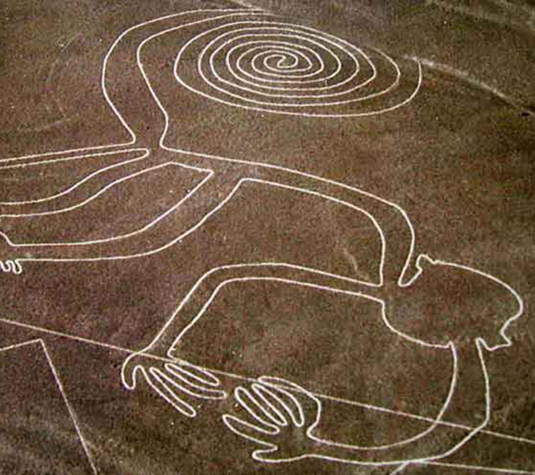
- Abstract designs: such as spirals, zigzags, and undulating shapes, whose meaning is still being investigated.
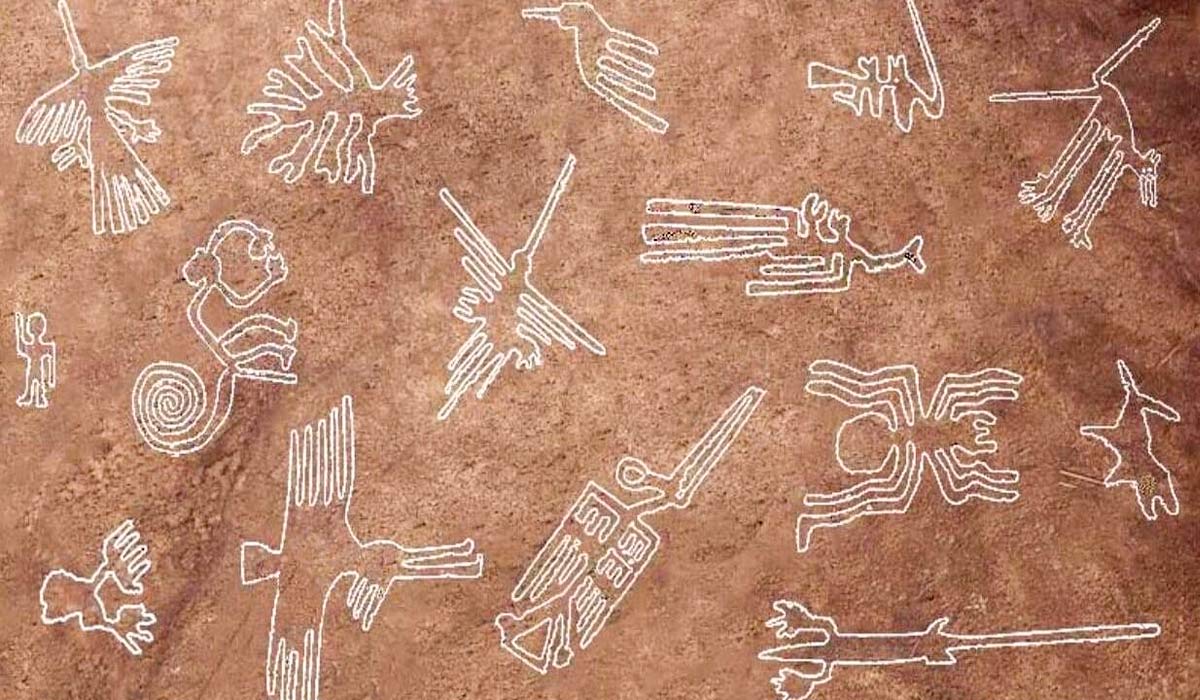
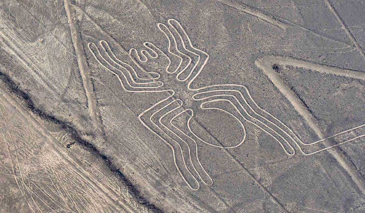
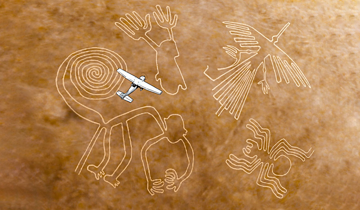
- Figurative figures: the most globally known, although numerically few (around 30). They represent animals such as the hummingbird, the monkey, the spider, and the dog, as well as fantastic forms that could reflect religious beliefs or visions of the supernatural world.
About the Nazca culture
The creators of these impressive works were the Nazcas, a pre-Inca culture that flourished between 200 BC and 800 AD, with its ceremonial center in the city of Cahuachi. This city, composed of pyramidal structures, was the spiritual and political heart of the civilization. The Nazcas practiced a complex funerary system. Their dead were wrapped in funerary bundles and buried in collective underground chambers. The extreme dryness of the desert helped to naturally preserve the bodies, which allowed for a ritual bond with the ancestors, whom they periodically visited to worship.
Location of the Nazca Lines
The Nazca Lines are located on the southern coast of Peru, mainly in the Pampa de San José, between the current provinces of Nazca and Palpa, in the department of Ica. This region is one of the driest on the planet, which has allowed the geoglyphs to be preserved for more than a thousand years. The designs extend over a vast desert plain, covering more than 500 square kilometers, and are located near the ancient ceremonial center of Cahuachi, the spiritual heart of the Nazca culture.
Beyond the lines: Nazca art and mythology
Nazca art is not limited to geoglyphs. Its polychrome pottery stands out for its representations of a supernatural world inhabited by hybrid beings: figures that combine human, animal, and even fantastic characteristics. Some of these mythological characters also appear in the geoglyphs. One of the most striking is the popular "killer whale", a marine creature that holds a knife and a decapitated head, a symbol possibly linked to rituals and sacrifices.
Agriculture in the desert
They settled in one of the world's most arid deserts, where rainfall is scarce and rivers are intermittent, yet they managed to develop agriculture that fed large populations. This success allowed for remarkable demographic growth, although, paradoxically, it may also have contributed to their decline.
Recent research indicates that the overexploitation of the huarango, the only native tree in the region, was a critical factor in the fall of the civilization. This tree not only provided essential wood for tools, construction, and cooking, but also played a key role in the conservation of the ecosystem. Its massive felling weakened the environmental balance, exacerbating the vulnerability of the Nazca agricultural system.
Hydraulic Engineering
How were the Nazcas able to sustain a growing population in such a hostile territory? The answer lies in their hydraulic engineering. This civilization designed and built a sophisticated system of aqueducts, filter wells, and underground channels that allowed them to capture and conduct groundwater to cultivation areas.
This system was not only innovative, but also efficient and sustainable, to the point that several of these aqueducts, known as puquios, are still functioning today, more than a thousand years after their construction. The existence of this system demonstrates the Nazcas' ability to adapt to the environment and transform the desert into a productive setting.
About their Geoglyphs
Unlike demanding agriculture, the creation of the famous Nazca geoglyphs required less technical effort, though it was not without meaning or visual impact. The topography and soil composition facilitated their elaboration: a superficial layer of dark stones covers a bed of light, compact sand. By carefully removing the stones from certain areas, the Nazcas revealed the lighter sand, creating a strong contrast.
The result: enormous figures that stand out due to the play of natural lights and shadows, reinforced by the contrast between swept areas and areas with intact stones. The extracted stones were arranged along the edges of the lines, further defining the design. Thus, without complex tools or the need for pigments, the Nazcas managed to express their worldview in the desert in a lasting way.
What were the Nazca Lines?
To create these enormous geoglyphs, the ancient Nazca builders worked with mathematical precision. It is believed that they started from small-scale designs, possibly drawn on cloth or tablets, which they then transferred to the ground using enlargement techniques, using ropes and stakes. Despite the widespread belief that they were designed to be seen from the air, the arrangement of the lines suggests otherwise. The figures overlap, intersect, and in many cases seem to lack overall planning. This indicates that there was no intention to create a coherent set visible from a great height, probably because the Nazca people never imagined that someday someone could contemplate them from the sky. Everything indicates that each line or figure was conceived independently, possibly at different times or by different groups.
What were the Nazca Lines for?
The purpose of these enigmatic figures has been the subject of multiple theories over the years. Although there is no definitive answer, four major hypotheses have gained relevance in archaeological research:
- Ceremonial paths
This theory, one of the most accepted, was initially proposed by the Peruvian archaeologist Toribio Mejía Xesspe. He proposed that the lines functioned as ritual paths used in ceremonies and religious processions. Recent research supports this idea, finding lines that lead directly to the sacred city of Cahuachi, suggesting that they were symbolic pilgrimage routes. - Astronomical calendar
One of the best-known proposals was that of Maria Reiche, a mathematician and passionate defender of the site. Influenced by her colleague Paul Kosok, she described the Nazca Lines as "the largest astronomy book in the world". Reiche believed that the lines were aligned with solstices, equinoxes, and the rising of celestial bodies. Although her ideas have been partially refuted by more recent research, the astronomical component is still considered a complementary possibility, especially in certain figures aligned with solar events. - Water maps and nature worship
Another line of interpretation links the geoglyphs with the most vital element for the Nazca people: water. Several researchers argue that the lines fulfilled ritual functions related to the worship of water and mountains (apus), sacred sources of the resource. The work of researcher David Johnson stands out, who suggests that the geoglyphs represent a symbolic map of the region's underground water system. Although promising, this hypothesis still requires more archaeological evidence to be confirmed. - Representations of the spiritual world
Some scholars suggest that the figurative designs are not only artistic, but representations of Nazca deities or scenes linked to religious experiences. It has been suggested that they could be related to shamanic journeys, possibly induced by the use of psychotropic substances, and that the figures constituted a visual language of the Nazca spiritual universe. This theory, however, is more difficult to prove due to the scarce direct information about the religion and ritual practices of this ancient culture.
Despite decades of research, the Nazca Lines remain a mystery in many aspects. What is clear is that they represent one of the most complex cultural expressions of ancient Peru, where science, religion, art, and the environment converge in a unique landscape. Whether as paths, calendars, water maps, or sacred symbols, these lines drawn on the desert land continue to challenge our understanding and astonish the world.
The Enigma Continues: Interpretations and Mysteries of the Nazca Lines
Although there are four main approaches to studying the Nazca Lines, astronomical, ritual, hydraulic, and geometric, other researchers have proposed complementary theories that broaden the debate. Some of these interpretations focus on the symbolism of the figures, seeing them as a kind of great visual atlas or even as a huge network of textiles, in reference to Andean textile art. On the other hand, some theories do not pay attention to the shape of the geoglyphs, but to their social function. An example is the proposal by archaeologist William H. Isbell, who suggests that the construction of these figures could have been a way to redistribute community work during periods of low agricultural activity. In this sense, the geoglyphs would have functioned as a system to maintain the social and economic cohesion of the Nazca community.
Between science and speculation
The mystery surrounding the Nazca Lines Peru has also generated numerous non-scientific interpretations, especially since the 20th century. The most popular of these theories was promoted by Erich von Däniken, who in the 1970s proposed that the lines were landing strips for extraterrestrial spacecraft. His vision, although without archaeological or historical basis, captured the public's imagination and gave rise to a cultural phenomenon around "ancient astronauts". These types of theories, although widely discredited by the scientific community, reflect the symbolic and enigmatic power that these figures still exert on the human imagination.
A mystery yet to be deciphered
Despite decades of research and technological advances in archaeology, many questions about the origin, purpose, and exact meaning of the Nazca Lines remain unanswered. However, this does not imply that their secrets are beyond human reach, nor that they come from outer space. The deepest answers about the geoglyphs are probably found in the spiritual universe of the ancient Nazca people, a complex worldview that we do not yet fully understand. This "other world", the sacred world of the Andean peoples, may seem as unattainable as the sky itself, but perhaps, with time and study, we can also "fly over" it with our minds and science.
Other interesting blogs:
- Where is Machu Picchu?
- Machu Picchu Tickets: Upgrade guide 2026
- Skylodge Adventures Suites
- Machu Picchu Weather
If you want to live this great experience do not hesitate to contact us. Reserve our guided trips to Machu Picchu by contacting our travel experts and you will be closer to completing your adventure: